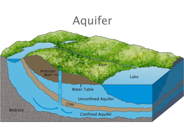
Hydrogeological surveys are critical for sustainable groundwater development, especially in water-stressed regions like Kenya. Before deploying costly drilling rigs or geophysical equipment, a desk study and literature review provide the foundational knowledge needed to minimize risks and maximize success rates. This phase involves compiling and analyzing existing geological, hydrological, and climatic data to identify viable borehole locations.
In Kenya, where groundwater availability varies drastically—from the high-potential aquifers of the Central Highlands to the arid, fractured systems of Turkana—a well-executed desk study can mean the difference between a productive borehole and a costly dry hole.
This article explores:
-
The importance of desk studies in hydrogeology.
-
Key data sources available in Kenya.
-
Step-by-step methodology for conducting a desk study.
-
Case studies demonstrating its impact.
-
Challenges and future improvements.
Why Conduct a Desk Study?
1. Cost Efficiency
Field surveys and drilling are expensive. A desk study helps prioritize high-potential zones, reducing unnecessary expenditures. For instance, in Kitui County, a 2021 study by the Water Resources Authority (WRA) found that 40% of proposed borehole sites could be eliminated through desk-based analysis, saving an estimated $200,000 in drilling costs.
2. Risk Mitigation
Historical data reveals:
-
Failed boreholes (e.g., low-yield or saline zones).
-
Contamination risks (e.g., fluoride in the Rift Valley).
-
Land-use conflicts (e.g., protected areas or mining zones).
3. Regulatory Compliance
Kenya’s Water Act (2016) and NEMA guidelines require environmental and hydrological assessments before drilling. A desk study ensures compliance by identifying:
-
Protected groundwater zones.
-
Existing water rights and permits.
Key Data Sources in Kenya
1. Government & Institutional Reports
-
Water Resources Authority (WRA) – Borehole logs, aquifer maps.
-
Ministry of Water & Irrigation – National water master plans.
-
Kenya Meteorological Department – Rainfall and climate trends.
-
National Environmental Management Authority (NEMA) – Environmental impact reports.
2. Academic & Research Publications
-
University of Nairobi – Hydrogeology theses and journals.
-
Kenyatta University – Studies on aquifer recharge.
-
IGAD Climate Centre – Regional groundwater assessments.
3. Remote Sensing & GIS Data
-
USGS Earth Explorer – Free satellite imagery.
-
FAO AQUASTAT – Global groundwater databases.
-
SERVIR-Africa – Geospatial tools for drought monitoring.
4. NGO & Private Sector Data
-
UNICEF Kenya – Rural water supply reports.
-
Water NGOs (e.g., WaterAid, SNV) – Community well inventories.
Methodology for Conducting a Desk Study
Step 1: Define Objectives
-
Is the borehole for domestic use, irrigation, or industry?
-
What is the required yield (e.g., 5m³/hr for a village supply)?
Step 2: Data Collection
-
Geological maps (e.g., from the Geological Survey of Kenya).
-
Hydrological records (river flows, aquifer tests).
-
Historical borehole logs (success rates, depths, yields).
Step 3: GIS & Data Integration
-
Overlay geology, rainfall, and existing wells to spot trends.
-
Use QGIS or ArcGIS to map high-potential zones.
Step 4: Gap Analysis
-
Identify missing data (e.g., no geophysical surveys in the area).
-
Plan fieldwork accordingly.
Case Study: Kajiado County
In 2022, a Kenya Rural Water Authority project used desk studies to:
-
Avoid low-yield zones by analyzing historical drilling data.
-
Reduce dry holes by 30%, saving $150,000 in wasted drilling.
Challenges & Solutions
| Challenge | Solution |
|---|---|
| Fragmented data | Centralize databases (e.g., WRA’s new groundwater portal). |
| Outdated records | Partner with universities for updated research. |
| Limited digital access | Use offline GIS tools like QField. |
Conclusion & Recommendations
A well-executed desk study is the smartest first step in hydrogeological surveys. It saves money, minimizes risks, and ensures regulatory compliance. Key recommendations:
-
Invest in GIS training for water engineers.
-
Strengthen data-sharing between government and NGOs.
-
Update Kenya’s hydrogeological maps for accuracy.
For borehole planners in Kenya, skipping the desk study is not an option—it’s the blueprint for success.