
Cost Differences in Hydrogeological Surveys Based on Location and Methodology in Kenya
Hydrogeological surveys are an essential prerequisite for drilling successful boreholes and developing sustainable groundwater resources. In Kenya, the cost of these surveys can vary widely depending on several factors, including geographical location, the specific survey methods used, depth of exploration, logistics, and the expertise involved. These variations significantly influence budget planning for water supply projects, especially in regions with limited resources…
Read more
Cost Breakdown of Hydrogeological Surveys for Borehole Siting in Kenya
Borehole drilling is a significant investment in Kenya, often costing hundreds of thousands to millions of Kenyan shillings. A crucial precursor to this investment is a hydrogeological survey, which informs whether groundwater exists, at what depth, and its potential yield and quality. While many investors, communities, and institutions understand the importance of this survey, few have a clear understanding of the…
Read more
Geophysical Survey Using Electrical Resistivity in Hydrogeological Surveys in Kenya
Among the most widely applied field methods in groundwater exploration, electrical resistivity surveys stand out for their cost-effectiveness, accuracy, and adaptability to varied terrains. In Kenya, where subsurface geology ranges from volcanic and metamorphic terrains to sedimentary basins and fractured basement rock, electrical resistivity techniques are essential tools in locating aquifers and estimating their depth, thickness, and extent. These surveys significantly…
Read more
Remote Sensing and Satellite Imagery Analysis in Hydrogeological Surveys in Kenya
Remote sensing and satellite imagery have become increasingly vital tools in hydrogeological surveys, offering a bird’s-eye view of the landscape and unlocking valuable data on geological structures, surface features, and hydrological systems. In Kenya, a country marked by diverse climatic zones and topographical variation, remote sensing is particularly useful for identifying promising groundwater sites—especially in remote or poorly mapped areas. This…
Read moreLiterature Review in Hydrogeological Surveys in Kenya
Before any boots hit the ground in a hydrogeological survey for boreholes or wells in Kenya, a crucial foundational step must occur: the desk study and literature review. This phase forms the backbone of any groundwater exploration initiative. It provides the contextual and technical information necessary to plan an effective and efficient field investigation. In Kenya, where diverse geological formations and…
Read moreCost Differences in Hydrogeological Surveys Based on Location and Methodology in Kenya
Rahm
- June 10, 2025
- 1135 views

The Role of Remote Sensing and GIS in Borehole Surveying in Kenya
- June 10, 2025
- 219 views
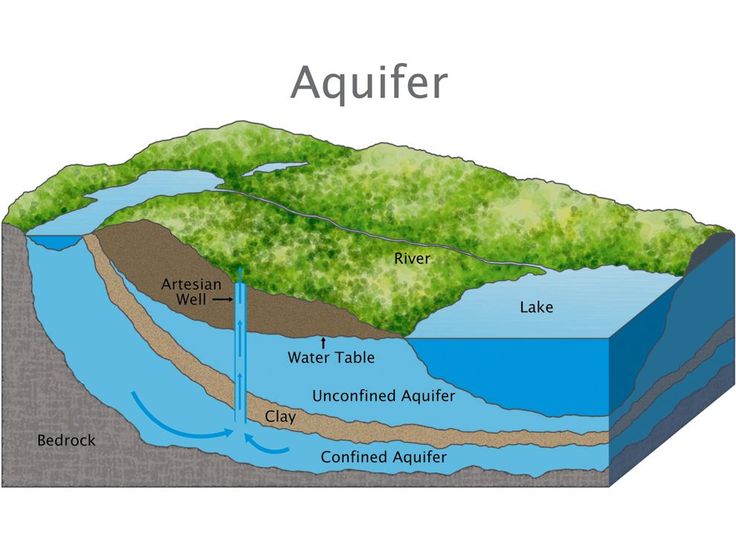
Understanding Aquifer Types and Groundwater Occurrence in Kenya’s Geological Formations
- June 10, 2025
- 663 views
Cost Breakdown of Hydrogeological Surveys for Borehole Siting in Kenya
- June 10, 2025
- 400 views

Hydrogeological Mapping and Field Reconnaissance in Kenyan Groundwater Surveys
- June 10, 2025
- 157 views