Hydrogeological mapping and field reconnaissance are foundational steps in any groundwater investigation. In Kenya—where geological formations vary from volcanic highlands and fractured basement terrains to sedimentary basins and coastal aquifers—understanding the hydrogeological context is essential before any borehole drilling begins. Hydrogeological mapping provides a visual and analytical representation of the subsurface water system, while field reconnaissance bridges the gap between desk-based interpretations and on-ground realities.
This article explores how hydrogeological mapping and reconnaissance are conducted in Kenya, their methodologies, applications, cost implications, and significance in the broader framework of water resource development.
What is Hydrogeological Mapping?
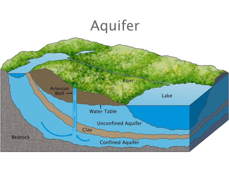
Hydrogeological mapping involves the integration of geological, hydrological, and geophysical data to understand the occurrence, movement, quantity, and quality of groundwater in a given area. A hydrogeological map typically shows:
-
Aquifer boundaries and characteristics
-
Geological formations and their water-bearing properties
-
Locations of springs, rivers, and wells
-
Recharge and discharge zones
-
Structural features like faults and fractures
In Kenya, such maps are crucial tools in siting boreholes and developing water resource management strategies, especially in rural and water-scarce regions.
The Role of Field Reconnaissance
Field reconnaissance is the physical inspection of the study area to validate information gathered during desk studies and remote sensing analysis. It involves:
-
Ground-truthing of geological features
-
Observing existing wells, springs, and surface water bodies
-
Mapping out access roads and topographical features
-
Collecting samples and measuring water levels
-
Engaging local communities for indigenous knowledge
Reconnaissance enhances accuracy in borehole siting, helps anticipate logistical challenges, and provides real-world context to desktop data.
Why Hydrogeological Mapping Matters in Kenya
Kenya’s hydrogeological complexity makes mapping a necessity rather than a luxury. Key reasons include:
1. Geological Diversity
From the volcanic rocks of the Rift Valley to the sedimentary aquifers along the coast, aquifer types vary greatly, influencing drilling depth, yield, and water quality.
2. Water Scarcity and Demand
With growing populations and increasing water stress, especially in ASALs, accurate maps guide resource allocation and sustainable use.
3. Climate Variability
Understanding recharge zones and groundwater vulnerability supports resilience against droughts and erratic rainfall.
4. Legal and Regulatory Compliance
A hydrogeological survey report, including mapping, is required by the Water Resources Authority (WRA) for borehole drilling approval.
Methodology of Hydrogeological Mapping in Kenya
Hydrogeological mapping typically follows a structured process:
Step 1: Desk Study and Data Collection
-
Review of geological maps (1:250,000 or more detailed if available)
-
Analysis of topographical maps and satellite imagery
-
Examination of borehole logs, water levels, and pumping test data from databases like the WRA or Ministry of Water
Step 2: Field Reconnaissance
-
Walkovers of the area to observe landforms, rock exposures, and drainage patterns
-
GPS-based mapping of visible features like springs, seepages, and existing wells
-
Interviews with local residents on seasonal variations, water history, and perceived groundwater depth
Step 3: Geological and Structural Mapping
-
Identifying rock types, contacts, faults, folds, and joints that control groundwater movement
-
Observing soil types and depth of weathering
Step 4: Hydrogeological Interpretation
-
Characterizing aquifer types (e.g., weathered, fractured, sedimentary)
-
Assessing recharge potential and water table conditions
-
Estimating sustainable yield and drilling depth
Step 5: Map Preparation
Maps are created using GIS software such as QGIS, ArcGIS, or Surfer, integrating field data with remote sensing and historical records.
Key Features Represented in a Hydrogeological Map
A comprehensive hydrogeological map in Kenya typically includes:
-
Lithological boundaries (e.g., tuff, basalt, schist, limestone)
-
Aquifer types and extents
-
Borehole and well locations with yield and depth data
-
Surface water features (rivers, wetlands, springs)
-
Lineaments and faults
-
Land use and vegetation cover
-
Groundwater recharge and discharge areas
-
Flow directions and water table contours
Tools and Equipment Used
-
GPS devices for accurate geo-referencing
-
Geological compass and field notebooks for rock orientation and structure mapping
-
Topographical and geological base maps
-
Measuring tapes and soil augers for shallow subsurface observations
-
Water level meters for measuring depth to water in existing boreholes
-
Cameras for visual documentation
-
Mobile GIS and field apps like Survey123 or Field Maps
Field Case Example: Taita Taveta County
A hydrogeological mapping exercise in Taita Taveta aimed to support rural borehole drilling initiatives. Findings included:
-
Presence of fractured basement rocks and deep weathered zones
-
Major lineaments trending northeast–southwest, acting as conduits for groundwater
-
Seasonal springs recharging valley-bottom aquifers
-
Recommended drilling depth: 100–150 meters in areas of intense fracturing
The integration of reconnaissance with geological mapping improved siting accuracy and increased borehole success rates.
Advantages of Hydrogeological Mapping and Reconnaissance
-
Informed Decision-Making: Reduces guesswork in drilling and improves success rate.
-
Sustainable Development: Helps estimate long-term yield potential and recharge capability.
-
Cost-Efficiency: Avoids drilling in unproductive areas and reduces redundancy in surveys.
-
Multi-Purpose Use: Maps can inform irrigation planning, water infrastructure development, and environmental conservation.
-
Risk Mitigation: Identifies geohazards such as fault zones, landslides, and saline water pockets.
Challenges and Limitations
-
Data Gaps: In many remote areas, up-to-date geological and borehole data are lacking.
-
Accessibility: Poor roads, rugged terrain, or insecurity may hinder field visits.
-
Complex Geology: Interpreting fractured basement terrains requires experience and sometimes geophysical confirmation.
-
Time and Cost: Thorough mapping requires time and expertise, which may raise costs for small-scale projects.
Integration with Other Survey Techniques
To enhance accuracy, hydrogeological mapping is commonly paired with:
-
Electrical resistivity surveys to verify aquifer depth and thickness
-
Remote sensing for lineament and land use mapping
-
Pump tests to assess aquifer yield and sustainability
-
Hydrochemical sampling for water quality mapping
Regulatory Role and Reporting
Hydrogeological mapping is a mandatory component of the hydrogeological survey report required by Kenya’s Water Resources Authority (WRA). These reports must include:
-
Map(s) showing geological and hydrogeological features
-
Site-specific recommendations for borehole drilling
-
Anticipated yield, water quality, and sustainability considerations
Conclusion
Hydrogeological mapping and field reconnaissance provide a scientific and practical foundation for groundwater exploration in Kenya. These methods help to understand complex subsurface conditions, improve borehole success rates, and promote the sustainable development of water resources. In a country where groundwater serves millions in rural and peri-urban areas, proper mapping is not only best practice—it is a critical step in securing water security for present and future generations.